Creating a digital map with multiple points
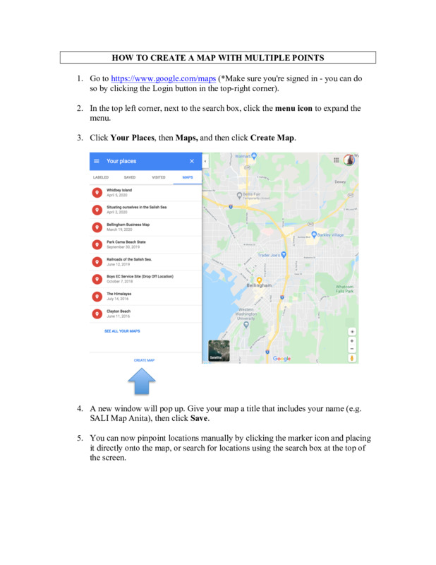
Pin the following locations within the Salish Sea on a google map. For step-by-step instructions on how to do this, see HOW TO CREATE A MAP WITH MULTIPLE POINTS.
For places you have personally been to, choose ORANGE as the color of the "marker" or "pin". For places, you have yet to go, choose GREEN.
|
|
|
2. Choose one of the locations to look up and do a little research about (*this should be a location that you have not been to or a GREEN pin on your map). Tell us which location you chose, and share 3 facts about it.
3. Choose a location within the Salish Sea that you feel a connection to (this may be a spot that you already have located on the map, or it may be somewhere that has not been yet identified - either is ok). Color code that "marker" to be RED. Write a brief story about why you feel connected to this particular place.
4. Post to the discussion board. Include a link to your map, three facts about a place you have not been, and your short story about the place you are connected to.
5. Explore your classmate's maps and read through each other's responses. Make a minimum of two additional posts on the discussion board (by Sunday at midnight).
Some things you might consider as you're exploring each other's maps, and making comments:
- Do you notice any interesting patterns?
- How much of this information is new?
- What new places are you excited about visiting?
- What places do you want to learn more about?
- Title
- Creating a digital map with multiple points
- Description
- Pin locations on a Google Map and share your research about the sites.
- Temporal Coverage
- Present
- Spatial Coverage
- Salish Sea
- Contributor
- Whatcom Community College
- Extent
- One hour
- Audience
- Online asynchronous
- Subject
- Social Sciences