
Items
Creator is exactly
Dr. Aquila Flower
-
Salish Sea Stream Discharge Diagram
Map of Salish Sea major rivers and average stream discharge in cubic meters per second based on annual averages. -
Salish Sea Land Cover
Map of land cover in the Salish Sea bioregion with the categories of urban, cropland, forest, other vegetation, bare ground, water, snow and ice land cover modeled using 30x30 meter resolution gridded satellite data from 2015. -
Salish Sea Population Density
Map of human population density in the Salish Sea as people per square kilometer mapped for each census block. -
Salish Sea Jurisdictions
Map of jurisdictions including U.S. counties, Canadian regional districts, and major cities (Bellingham, Everett, Olympia, Seattle, Tacoma, Vancouver, and Victoria) in the Salish Sea Bioregion.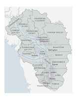
-
Salish Sea and Western North America Watersheds Contextual Landscape
Map of the Salish Sea’s surrounding watersheds in Western North America, including the Columbia, Fraser, Great Basin, Makenzie, Mississippi, Nelson, Yukon. The Pacific Ocean and Arctic Ocean are also visible.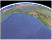
-
Marine Basins
Map of subbasins (or sub-basins) and bathymetry of the Salish Sea with basins delineated based on water depth and circulation. Shallower areas associated with underwater sills separate many of the basins, creating distinct oceanography. Basins shown include: Admiralty Inlet, Central Puget Sound, East Strait of Juan de Fuca, Hood Canal, South Puget Sound, San Juan Archipelago, South Strait of Georgia, Strait of Georgia, West Strait of Juan de Fuca, and Whidbey.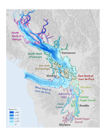
-
Salish Sea Circulation Diagram
Diagram of deep water flows and intermediate and surface water flows in the Salish Sea. It provides direction and relative magnitude (line width) of net water flow and exchanges for marine waters and freshwater rivers.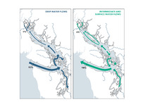
-
Where is the Salish Sea?
ArcGIS StoryMap of the geography of the Salish Sea Bioregion, containing maps and facts about the bioregion, the Coast Salish peoples, waters and islands, watersheds, and more data resources.