Salish Sea Circulation Diagram
Item
-
Title
-
Salish Sea Circulation Diagram
-
Description
-
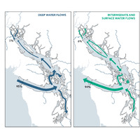
Diagram of deep water flows and intermediate and surface water flows in the Salish Sea. It provides direction and relative magnitude (line width) of net water flow and exchanges for marine waters and freshwater rivers.
-
Abstract
-
Direction and relative magnitude (line width) of net water flow in the Salish Sea. Deep water flows represent primarily marine waters entering the Salish Sea from the Pacific Ocean. Intermediate depth and surface flows represent a mix of marine waters and freshwater from rivers in the Salish Sea. Actual circulation patterns are highly complex and seasonally variable, this diagram shows a simplified model of net exchanges. Labels indicate percent of the total water exchange that moves in and out of the Salish Sea through the Strait of Juan de Fuca in the south and through the northern boundary of the Strait of Georgia.
-
Type
-
map
-
Date
-
2021